Travelling back from a work meeting on the train can be a great chance to get some focus time and immerse yourself. So I’m catching up with the latest update to ArcGIS Online and wanted to share my highlights (spoiler alert Arcade support has been added to ArcGIS Experience Builder). So, apologies for any shoogly typing and hope you spot something in the updates that makes your tasks easier or improve your workflows.
Product access expanded through user types
The planned changes we shared with you earlier in the year have arrived. The following products are now available to more users: ArcGIS Business Analyst Standard, ArcGIS CityEngine, ArcGIS Urban and ArcGIS Navigator. For a walk-through of these changes and the products you can still catch up with our ‘ArcGIS Update’ GISt Live webinar update here.
Items page
One of the first things you’ll notice is a new look to the Item page, which allows you to show and hide the elements to simplify the view.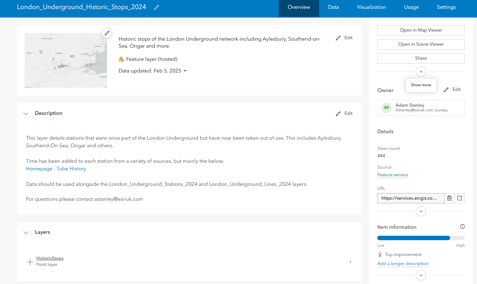
The Data tab has also been enhanced with some new options and, to make it consistent with ArcGIS Pro, value lists and ranges have been renamed to list and range domains respectively. If you are using field calculations, take a moment to familiarise yourself with the new layout – I momentarily lost the Next / Run calculation button.
Map Viewer
A new option has been added to the Counts and Amounts mapping styles: Spike (see below). If you are working with range based symbology the detail in an area of interest can be masked by the symbology being tailored to the full data range. Now you can re-generate the symbology based on the data in the current extent.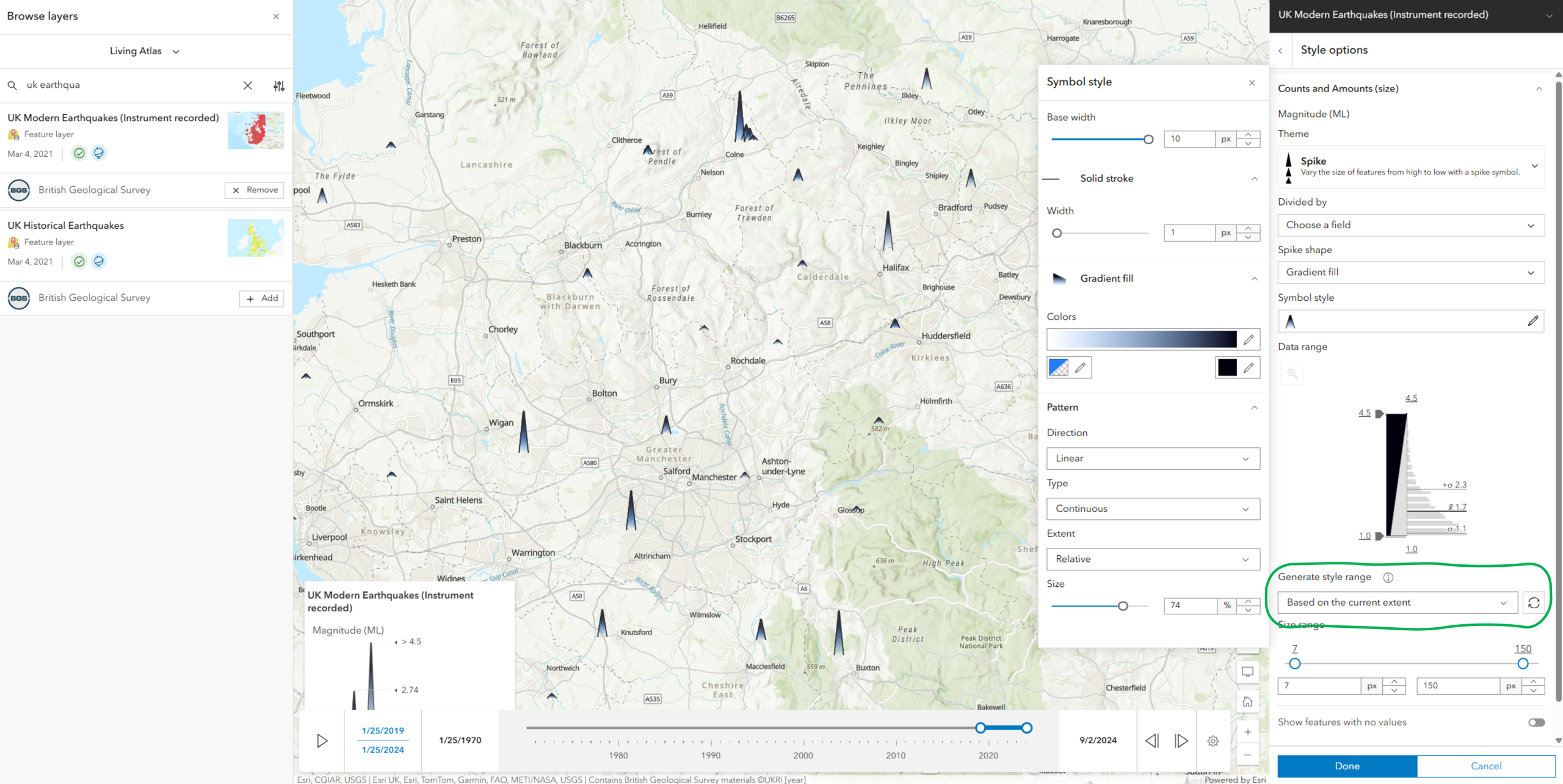
A lot of web maps are created to support an app, but if you want to share a map directly you can now create a short link that includes the current map extent. If you need to add mark up to help explain something then using Sketch is a map specific way to add text, arrows etc… and you can now do curves.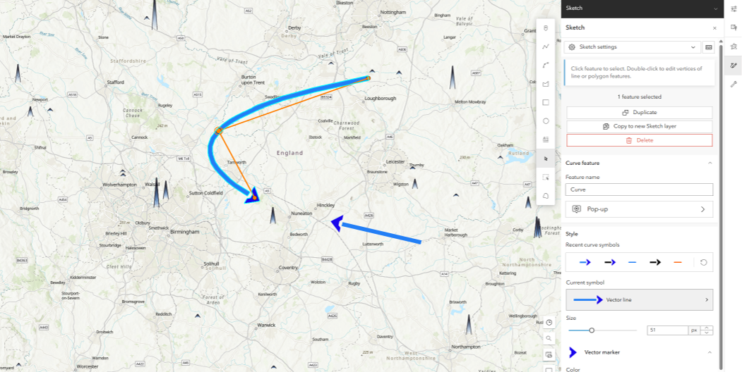
If you are embedding a web map you can now choose to preserve the scale of the map. You can then be confident that if the map is viewed on a different sized screen the same layers will be be visible.
Arcade is a great way to enhance your maps but, if you are new to it or only an occasional user, figuring out the expression you need can be time consuming. This might be about to get easier with a new AI driven Arcade Assistant (currently in beta).
Web app builders
ArcGIS Instant Apps
Two of the templates, with similar functionality, have been merged – so Basic and Media Map are now a single template called Basic (Media Map). There is no loss of functionality and all settings are still available. Any apps created with the original Media Map template are still configurable and can be accessed on the My Apps tab of the Instant Apps home page.
The attribute filter feature is included in several of the templates and the configuration experience had an overhaul in this update. It now uses more screen space, so it’s easier to see the filters you are setting up.
The Manager app template – which lets you review and edit data from multiple maps and layers – now supports selecting multiple features and batch editing.
There is also a new template, out in beta, but you’ll need to read on to find out about that one…
ArcGIS Dashboards
As well as some new header styling options, Dashboards supports new date field types for; date only (EsriFieldTypeDateOnly), time only (EsriFieldTypeTimeOnly) and timestamp offset (EsriFieldTypeTimestampOffset).
ArcGIS Experience Builder
As a fan of the flexibility that Experience Builder offers and the power of Arcade to enhance all sorts of things, it’s no surprise that the conjoining of these is the update I’m most excited about. Arcade expressions can be added to the dynamic styling of Text widgets, Button widgets and list items in the List widget. Arcade can also be used to add data sources to an app.
There are lots more enhancements including new Triggers and Actions, new widgets and enhancements to existing ones. So check through the What’s New page to get the full run down.
Analysis and data management
The big news here is that ModelBuilder in ArcGIS Online is out of beta. It also gained a Filter by Attributes tool, among other enhancements.
ArcGIS Notebooks now includes the new versions of ArcGIS API for Python, ArcPy, and Python libraries.
Data Pipelines – a no-code data engineering tool – has a new clip tool to cookie cut data based on geometry from another layer. Two beta features have been added: connection to Databricks and securely connecting to URLs or APIs that require authentication.
Web editing
It’s only a few weeks since we explored the web editing options at our conference… and along comes the next expansion. Along with a field calculator, the ArcGIS Web Editor has a companion Instant Apps template, called Web Editor. Why? Suppose you want to give users access to some options but not everything – you can try this beta Instant Apps template to configure your editing tools.
Learn about the rest
It turns out the list of new features in this update is longer than my train journey, so I’m going to wrap things up. For the imagery enhancements I’ll refer you to this blog. You can learn more about ArcGIS Excalibur, now in general release, here. Or to find out more about the rest of the release try these:
- What’s New documentation page – for the full list of changes
- What’s new blog for an extended overview and a video guide
- Or browse these blogs to dig deeper into some of the changes